Summary
 The
Okavango Delta, in the midst of the Kalahari sands, is Africa's largest
and most
beautiful oasis. The River Okavango, which rises in the highlands of
Angola, never reaches the sea; instead, its mighty waters empty over
the sand
of the Kalahari Desert. Here the thirstland of the south meets a blue-green
wilderness of fresh water, with emerald reedbeds and towering trees. The
Okavango Delta, in the midst of the Kalahari sands, is Africa's largest
and most
beautiful oasis. The River Okavango, which rises in the highlands of
Angola, never reaches the sea; instead, its mighty waters empty over
the sand
of the Kalahari Desert. Here the thirstland of the south meets a blue-green
wilderness of fresh water, with emerald reedbeds and towering trees.
The Okavango
Delta is one of the world’s greatest mysteries – water
in a desert! The Kalahari Desert is the largest continuous stretch
of sand in the
world and within it lays the magnificent Okavango delta, an area that
is home to a myriad of animal and bird species. The area is a magnificent
expanse of waterways, floodplains, forested islands and lagoons that
covers about 18,000 sq kms.
This African oasis originates from a catchment
area in Angola called the Cubango River that flows southeast through Namibia
as the Kavango River and finally enters Botswana 1000 miles later as the
Okavango River. Once here the fate of the River is determined by a series
of parallel fault lines that lie deep below the desert surface. Once the
river passes over the first fault line, known as the Gomare fault, it
splits up into several waterways and channels that spread out and create
that fan like pattern that is actually visible from space. When the water
finally reaches the final two fault lines, known as the Kunyere and Thamalakane
faults, the water is literally dammed up here and disappears into the
Kalahari in an almost magical fashion.
The Okavango Delta consists of luxury
safari camps that vary in activities from pure game viewing camps to mixed
activity camps or pure water based activity camps. |
Formation of the Delta
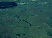 The continent
of Africa is currently being split apart by geological processes along
the enormous Great Rift Valley which starts north in Ethiopia, passes
through Kenya, Uganda and Tanzania. In Tanzania, it divides to cut through
Malawi and Mozambique to the east and to the southwest through Zambia's
Luangwa Valley and Kariba Valley to Victoria Falls. From Vic Falls, it
continues southwest to form the rift-system through the Chobe-Linyanti
area to the Okavango Delta at its southwest extremity where it is at its
smallest. The continent
of Africa is currently being split apart by geological processes along
the enormous Great Rift Valley which starts north in Ethiopia, passes
through Kenya, Uganda and Tanzania. In Tanzania, it divides to cut through
Malawi and Mozambique to the east and to the southwest through Zambia's
Luangwa Valley and Kariba Valley to Victoria Falls. From Vic Falls, it
continues southwest to form the rift-system through the Chobe-Linyanti
area to the Okavango Delta at its southwest extremity where it is at its
smallest.
This latest
opening of the rift forming the Okavango Delta is recent in geological
terms - within the last 3 million years. The Delta was formed where
this
latest portion of the rift cut through the center of the Kalahari sand
sheet in a southwesterly direction. The main Okavango rift lies between
two parallel fault lines - one at the lower extremity of the Delta
passing
through Maun (the Thamalakane fault) and the other at the northern edge
of the Delta along the line of the Selinda Spillway (the Gomare fault).
The area of land between the two southwesterly faults has dropped about
300 metres.
Because the
geological tension that is splitting the southern African continent is
east-west (instead of NW-SW like the rift), there are a series of minor
fault lines at right angles to the major Okavango rift. The most prominent
of these minor faults have created a minor rift forming the Okavango "panhandle"
or the main Okavango River which empties into the Delta from the Northwest.
The area of land to the immediate east of this rift has become slightly
elevated forming Chief's Island.
Before the
Okavango rift formed, the Okavango River flowed directly through the area
where the Okavango Delta is now, through what is now the Lakgadikgadi
Pans and probably out to the Indian Ocean via the Limpopo River. When
the Thamalakane fault at the lower edge of today's Delta rose up, the
Okavango River's flow was blocked and this initiated the Delta's formation.
As the Okavango's
rift subsided, it filled up with a mix of windblown sand from the Kalahari
and with water-borne sediments carried into it by the waters of the
Okavango
River until it assumed it's present day form as a major inland alluvial
fan. The major ingredients of the Delta today are the flat, dry, infertile
Kalahari sand sheet, intersected by a shallow rift valley trough, with
a major river flowing into this trough along a minor fault line - the
"panhandle". The water and nutrients carried in by the river
accumulate in the trough and give rise to the biological productiveness
and beauty of today's Okavango Delta. |
The Dynamics of the Delta
An essential feature
of the Delta is that it is highly dynamic and changes from year to year
depending on the flood waters and rains as well as the ever-changing flow
of the waters through the Delta. It is this dynamic
nature that prevents the Delta from becoming poisoned with salts as the
Makgadikgadi Pans did. This dynamism also leads to the great diversity
of water depth, soils, vegetation and animal distribution found in the
region.
Before about 30,000 years
ago, Northern Botswana was much wetter than it is today and the Delta
wetlands much larger. A huge inland lake extended from the Kwando / Linyanti
Rivers via the Savuti Channel to the Mababe depression and along the Thamalakane
River to Lake Ngami and via the Boteti River to greater Lake Makgadikgadi.
After a number of climate
fluctuations (per the ice ages), the last very wet period was around 2,000
years ago when the Mababe Depression formed a lake connected Lake Ngami
via the Thamalakane River. The last 2,000 years have seen a progressive
drying up of the Delta as rainfall has decreased. In recent times, there
have been some periods of fluctuation between relatively wet and dry as
follows: 1850's = relatively wet; 1880-1955
= dry spell; 1955-late 1970's = wet spell;
since then progressively dryer. The years 1993-97
saw the lowest rains since records began in the 1920's. However, flood
levels have been slightly higher in the years 1998-2001
with this year's floods being lower than 2001.
 For
the latest info on this year's Okavango flood, click Okavango
Flood For
the latest info on this year's Okavango flood, click Okavango
Flood
The Seasons of The Delta
 The Okavango receives water from
two different sources at two different times of the year. The first is
the annual seasonal flood whereby rainwater in the Angolan highlands falls
in December and slowly makes its way down to the Delta a couple of months
later. The annual rainfall in the highlands of Angola is considerably
higher than in Botswana. Rainwater collects within this huge catchment
and is channelled down the Okavango river, creating a flood-tide of water
which gradually arrives at the Delta. In the upper reaches of the Delta,
the river reaches a peak height in February or March, and so the Panhandle
is the only area to receive the floods at the same time as the local Delta
rains. The Okavango receives water from
two different sources at two different times of the year. The first is
the annual seasonal flood whereby rainwater in the Angolan highlands falls
in December and slowly makes its way down to the Delta a couple of months
later. The annual rainfall in the highlands of Angola is considerably
higher than in Botswana. Rainwater collects within this huge catchment
and is channelled down the Okavango river, creating a flood-tide of water
which gradually arrives at the Delta. In the upper reaches of the Delta,
the river reaches a peak height in February or March, and so the Panhandle
is the only area to receive the floods at the same time as the local Delta
rains.
As the flood travels down
the river bed of the Panhandle, it overflows its banks, revitalizing the
swamps and covering the sandbanks. On reaching the fan-shaped Delta, it
spreads out overflowing river channels and the banks between clumps of
reeds and papyrus, inundating floodplains and slowly raising the water
level in lagoons and backwaters. Plants in and around these seasonal swamps
thrive once again with the higher ground areas continuing to dry up from
lack of rain. The flood's front moves slowly, travelling at speeds of
only one kilometre per day - (it takes 4 months for the incoming floods
to travel the 250km from Mohembo in northern Botswana to Maun). This is
due to both the very shallow gradient (only 65 metres) over this distance
and because the water is slowed by the swamp vegetation. Thus, the floodwater
reached much of the southern half of the Delta in the middle of the "dry"
season.
As the floods subside and
the water levels recede, the hot onset of Spring and summer peak with
the very hot and dry month of October when dust and airborne sand particles
create spectacular sunsets. The second rush of water comes with the
local
seasonal rains that fall over the Delta in the summer months (December
through March). These rains are not like the monsoons of Asia, but
rather
localized thunderstorms that are usually brief but potent and it usually
does not rain two days in a row. The rains usually abate with the onset
of April and dry up quickly but leave behind a lush, green carpet of
grasses
and new plant life.
The Okavango is constantly
changing as the water moves through the channels (and with it, the animals
that follow the water). The amount of water and when it arrives is all
dependant on the amount of rainfall locally and in Angola and it therefore
fluctuates on a yearly basis. |
The Delta's Water
 Only around 2% of the floodwater reaches Maun
in a good year. About 95% escapes into the air via evapo-transpiration
and a small fraction seeps into the underlying groundwater. Because most
of the Delta's water is lost to evapo-transpiration, salts and minerals
from the Okavango River are deposited and left behind in the Delta. Only around 2% of the floodwater reaches Maun
in a good year. About 95% escapes into the air via evapo-transpiration
and a small fraction seeps into the underlying groundwater. Because most
of the Delta's water is lost to evapo-transpiration, salts and minerals
from the Okavango River are deposited and left behind in the Delta.
The Okavango's water is lowest
from November to January when floodwater is confined to the permanent
swamps, an area ~ 4,000 sq. km. Flood levels in the Delta are highest
between March and September, depending on where one measures. At peak
flood, an additional 4,000 to 5,000 sq. km. of seasonal swamp and floodplain
are covered by the flood.
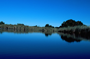
The water of the Okavango
is clean and pure and it is even safe to drink straight from the flowing
channels. The water tends to be stained to the color of weak tea by
plant
tannins, but this does not affect the purity of the water. The taste
of the water may also seem strange to some due to the presence of mineral
salts, but again, this does not pose any health hazards. There is no
industry
in the northern Delta and no agriculture to speak of, so the water coming
in is untainted and natural. Additionally, the waterways of the Delta
are
generally shallow so that light penetration is quite good; this presents
very poor conditions for micro-organisms and bacteria to flourish.
Finally,
the water is continually refreshed through the seasonal cycles of the
Delta and as it flows into the channels, it is finely filtered as it
passes
through hundreds of kilometres of papyrus beds and sandbanks. |
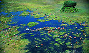
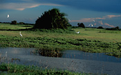
The Topography of
the Delta
Apart from the permanent
channels, the Delta is covered by shallow water, flooded grasslands, backwater
swamps, ox-bow lakes and hidden lagoons, mostly interconnected by narrow
waterways. The region is a complex of perennial and seasonal swamps and
floodplain grasslands. The seasonal swamps are only flooded during high
water, when the rivers spill their banks and inundate vast tracts of land.
The floodplains are only intermittently covered, depending on rainfall
or the direction and intensity of the river's flow that year. Change is
the essence of the Okavango's waterways.
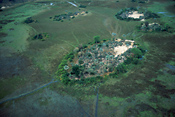
Scattered
throughout the Okavango Delta are literally millions of islands. Together,
they constitute an area equal to that covered by the Delta's water.
In
all shapes and sizes, they rise just high enough above the surrounding
reedbeds and floodplains to support the growth of trees. Ensured of
a
regular water supply, the woodlands that fringe the islands grow lofty
and luxuriant with species that could otherwise never survive on the
impoverished
Kalahari sands.
There are
an estimated 50,000 islands scattered throughout the Delta and they
are
dazzling in their numbers and variety of form. In the northern permanent
swamps they are hillocks so small that there is only room for a single
grove of the graceful Date palm, Phoenix reclinata. In the seasonal
swamps
of the middle Delta they become larger, their perimeters edged by a narrow
band of woodland comprising an assortment of lovely trees - Jackalberry,
Mangosteen, Knobthorn, and Sycamore Fig.
 Each island
is unique in the mix of trees it supports. The islands are formed in
a
variety of ways, most developing from small nuclei. Some begin as elevated
feature like termite mounds (see below), or as abandoned channel beds
that remain after the water course has been blocked by vegetation (mostly
papyrus) and switched to a new channel. Their original shape is usually
etched in their eventual form, so islands that started as termite mounds
are typically round, while those that formed out of former channel
beds
tend to be long and sinuous. Other islands - the massive Chief's Island
being a notable example - are the result of tectonic activity. Each island
is unique in the mix of trees it supports. The islands are formed in
a
variety of ways, most developing from small nuclei. Some begin as elevated
feature like termite mounds (see below), or as abandoned channel beds
that remain after the water course has been blocked by vegetation (mostly
papyrus) and switched to a new channel. Their original shape is usually
etched in their eventual form, so islands that started as termite mounds
are typically round, while those that formed out of former channel
beds
tend to be long and sinuous. Other islands - the massive Chief's Island
being a notable example - are the result of tectonic activity.
Towards
the southern end of the Delta, the islands are quite different. Sometimes
called sandveldt tongues, they are extensive areas of Kalahari sand
which
penetrate deep into the Delta, reminders of the more arid origins of
this oasis. The largest, Chief's Island, covers more than 1,000 square
kilometers
of the central Delta and supports vegetation and animal life more typical
of the dry deciduous Kalahari woodlands to the east and north. All
the
larger islands are fringed by a wide margin of floodplain grassland which
is inundated each year by floods only to reappear green and replenished
once the waters have passed through.
Most of
the smaller islands owe their existence to those ancient builders,
the fungus-growing
termites. Their activity not only raises patches of land above the general
flatness of the Kalahari, but their earth-moving endeavors also enrich
the soil, which in turn aids the growth of trees. The termite islands,
or 'termitaria', also play an important role in the Delta's pattern
of
water flow, particularly in the seasonal swamps. Termitaria may be built
in the narrow entrances to floodplains or is seasonally flooded lagoons.
As they grow, their bases join together so that the land rises and
prevents
the flow of water into the formerly flooded area. With time, the dried
floodplains are colonized by trees. If several islands are closely
situated,
the continued activity of the termites will cause them to join and a
larger islands is formed. In this way, the lands of the Delta and its
waterways
are constantly changing. |
The Delta's Wildlife
The process of renewal and the many habitat
types found in the Okavango Delta enable it to support a remarkable number
and diversity of life forms, among them 164 species of mammal, more than
400 of bird, 157 of reptile, 84 species of fish and over 5,000 different
insects.
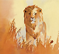
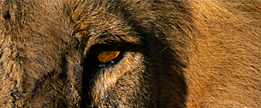
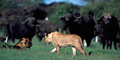 The most visibly evident
and sought after of the Delta's wildlife are the mammals. Four of
the
so-called "Big Five" (originally a hunting term used to describe
Africa's most dangerous animals and now the prime quarry of the visiting
safari game-viewer) are regularly seen by those visiting the Delta, namely
lion, leopard, elephant, buffalo. Tragically, as is the case in most
safari
destinations, the fifth of this group, the rhino, has been relentlessly
persecuted, poached to the brink of extinction for its horn. However,
early in 2002, Wilderness Safaris (the prime safari camp operator in
the
Delta) in conjunction with Botswana's Department of Wildlife and National
Parks have begun the process of reintroducing White Rhinos on Chief's
Island (at Mombo camp). Fifteen White Rhino's have been released so
far and they are doing well and are seen regularly around Mombo and Chief's
camps.
Click the following
link
to read more about the Safari
Updates. The most visibly evident
and sought after of the Delta's wildlife are the mammals. Four of
the
so-called "Big Five" (originally a hunting term used to describe
Africa's most dangerous animals and now the prime quarry of the visiting
safari game-viewer) are regularly seen by those visiting the Delta, namely
lion, leopard, elephant, buffalo. Tragically, as is the case in most
safari
destinations, the fifth of this group, the rhino, has been relentlessly
persecuted, poached to the brink of extinction for its horn. However,
early in 2002, Wilderness Safaris (the prime safari camp operator in
the
Delta) in conjunction with Botswana's Department of Wildlife and National
Parks have begun the process of reintroducing White Rhinos on Chief's
Island (at Mombo camp). Fifteen White Rhino's have been released so
far and they are doing well and are seen regularly around Mombo and Chief's
camps.
Click the following
link
to read more about the Safari
Updates.
In addition to the Big Five,
the Delta's array of mammals includes, among many others, cheetah, giraffe,
hippopotamus, many species of antelope, zebra, buffalo, primates such
as chacma baboon and vervet monkey, hyenas and crocodiles. Specialties
of the Okavango include the Red Lechwe and Sitatunga (both water dependent
antelopes), the African Wild Dog (a very rare and endangered animal),
Wattled Cranes, and Pel's Fishing Owl. |
Which time of year
is best to visit The Delta?
Each period of the year offers different highlights
to the traveler visiting the Delta. Most of the literature states that
the July thru October period guarantees the best wildlife viewing opportunities.
It is generally true in any wildlife area that the drier times mean better
game viewing because all the animals are forced to visit the water holes
and pans in order to drink each day. The predators then simply have to
wait near the water sources (which are fewer in dry season and therefore
more crowded) for the prey animals to come to drink. For a first-time
traveller or those with only a few days to spend, this may be the wisest
choice of times to go on a safari.
However, the wetter periods
during the rainy season (December through March in the Delta) offer spectacular
highlights which should not be overlooked. Photographically and aesthetically,
the colors of the Delta are far richer with the lush green growth everywhere
and the dramatic and sometimes stormy skies in the background. Additionally,
many of the herbivores such as the Impalas typically have their babies
during the rainy season to take advantage of the abundance of nutritious
grasses for the young to feed on after weaning. During the rainy season,
there are literally babies everywhere and, naturally, many are preyed
upon by the major predators as well, offering ample opportunity to see
more lions, leopards and cheetahs and wild dogs to name a few.
 Top
Top  Return to Map of
Okavango Delta
Return to Map of
Okavango Delta
Water
/ Land Activity Table for Botswana camps: Water/Land
Botswana
Flying
Times between Botswana camps: Fly
Times Botswana
For further information about Botswana, click More
Botswana
For further information about the Moremi Game Reserve, click More
Moremi
|