Namibia's
National Parks - Safari Information
Etosha National
Park
 Ranked
among the largest and most fascinating of Africa's game sanctuaries,
Etosha
National Park is home to a staggering diversity of animal, bird and
plant life. For centuries, Etosha was utilized as grazing and hunting
land by resident
tribes people,
such as the
Owambos, and the Hereros and nomadic
bushman hunters/gathers. It was unknown to Europeans until 1851,
when Swedish explorer Charles John Anderson and his companion Francis
Galton, an English scientist and cousin of Charles Darwin, opened
wagon tracks across the vast wilderness. In the years following,
there were many travelers, some of whom had left the South African
Transvaal, crossing the harsh interior of the Kalahari desert in
search of new
promised
land in Damaraland. In 1876, an American trader, G. McKiernan, traveled
northwards via Okoquea (present day Okaukuejo) and wrote in a letter
about the abundant wildlife: "All the menageries in the world
turned loose would not compare to the sight I saw that day." Etosha
and the surrounding areas became known as a hunter¹s paradise,
and it was not until 1907 that Dr. F. von Lindequist, Governor of
German South West Africa (as Namibia then was called), expressed
concern over the diminishing numbers of wild animals. He proclaimed
a reserve
of 99,526 square kilometres (61,843 miles) for the protection of
indigenous plants and animals. There were no fences or physical boundaries,
and the game was in no way restricted in its movements. Migration
across the game boundaries was not interfered with; it only meant
that the animals were no longer protected when and if they crossed
the boundary. Trading and farming were not even prohibited in the
reserve, although the wildlife was protected. Ranked
among the largest and most fascinating of Africa's game sanctuaries,
Etosha
National Park is home to a staggering diversity of animal, bird and
plant life. For centuries, Etosha was utilized as grazing and hunting
land by resident
tribes people,
such as the
Owambos, and the Hereros and nomadic
bushman hunters/gathers. It was unknown to Europeans until 1851,
when Swedish explorer Charles John Anderson and his companion Francis
Galton, an English scientist and cousin of Charles Darwin, opened
wagon tracks across the vast wilderness. In the years following,
there were many travelers, some of whom had left the South African
Transvaal, crossing the harsh interior of the Kalahari desert in
search of new
promised
land in Damaraland. In 1876, an American trader, G. McKiernan, traveled
northwards via Okoquea (present day Okaukuejo) and wrote in a letter
about the abundant wildlife: "All the menageries in the world
turned loose would not compare to the sight I saw that day." Etosha
and the surrounding areas became known as a hunter¹s paradise,
and it was not until 1907 that Dr. F. von Lindequist, Governor of
German South West Africa (as Namibia then was called), expressed
concern over the diminishing numbers of wild animals. He proclaimed
a reserve
of 99,526 square kilometres (61,843 miles) for the protection of
indigenous plants and animals. There were no fences or physical boundaries,
and the game was in no way restricted in its movements. Migration
across the game boundaries was not interfered with; it only meant
that the animals were no longer protected when and if they crossed
the boundary. Trading and farming were not even prohibited in the
reserve, although the wildlife was protected.
Today, Etosha National Park is
still one of the largest national parks, although its size has been
reduced (as of 1967) to only 22,270 square
kilometres (13,838
miles or about the size of Switzerland).
The park is surrounded by a strong wire, sometimes electrified fence,
which is intended to keep animals in and poachers out. In 1851,
C.J. Anderson had described Namutoni, at the Eastern end of the Etosha
Pan, as a needed and "most copious fountain" that the Owambo
people used as a cattle post. In 1896, in response to repeated skirmishes
between white settlers and the Owambo, a German military outpost was
established in Namutoni, and a fort was built there three years later.
In 1904, the fort was attacked and burned down by the Owambos. The fort's
seven German defenders were forced to run for their lives, making their
escape under cover of darkness. The fort was rebuilt later as a police
and veterinary outpost for the control of rinderpest, which had spread
from Bechuanaland (now Botswana).
Etosha's central feature, other than its wildlife, is the 3,811 mile
(6,133 square kilometre) Pan, once an inland sea. The Pan gradually dried
up through evaporation 2 to 10 million years ago when climatic changes
and topographic movements caused the Kunene river to change its course,
and to flow into the Atlantic Ocean. Now, the Etosha Pan is a stark,
seemingly endless depression of pale greenish-white clay, silt and mineral
salts, all baking under the fierce African sun.
In living history, the Etosha Pan has never been filled with water, although
in years of good rainfall, several tributaries of the Kunene river, such
as the Oshigambo and the Ekuma in northwest and the Omuramba Ovambo in
the east, drain into it, causing partial flooding and attracting thousands
of flamingoes and other wading birds. The water, though, can be as much
as two times saltier than sea water is, and therefore generally unfit
for animal consumption.
One of the harshest and most barren areas on Earth, Etosha seems to forbid
life. However, the Pan and the surrounding sweetveld savannah plains are
home to more than 114 mammal and some 340 bird species. This animal life
is sustained only because of underground springs that form waterholes on
the outskirts of the pan. These waterholes allow animals to fight off the
dry and the heat as they migrate across Etosha, seeking refuge from temperatures
that can reach as high as 120 degrees Fahrenheit.
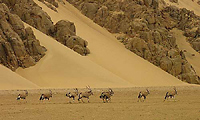
Etosha is famous for its huge Elephant population which is most visible
from July to September in the center of the park. When the rains begin
in December-January, many Elephants migrate north to Angola and west to
Kaokoland and only return again beginning in March. Large populations of
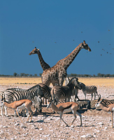
Zebra, Wildebeest, Springbok and Gemsbok migrate into Etosha westward from
the Namutoni area around October-November.
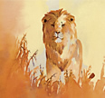
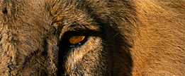
Lion are commonly seen in Etosha and Zebra are often sighted even way out
on the barren pan where Lions have no cover from which to stage an ambush.
Black-faced impala and Damara Dikdik, one of Africa's smallest antelopes
are two of Etosha's "specials". Rhino, both White and Black, occur throughout
the park. Leopard are also commonly seen.
Bird life is prolific, with over 325 species recorded, particularly on
the Etosha Pan during the rainy summer season from mid-January to March. However,
a large range of birdlife may be seen in the park year-round. Kites, Pelicans,
Greater and Lesser Flamingos, and Marabou Storks migrate seasonally.
 Top Top
Skeleton
Coast Park
 The Skeleton Coast
of Namibia - once an area feared and shunned because of its treacherous
coastline - is now prized as a place of beauty and tranquility; a
place of magnificent solitude. The area is located where the Namib
Desert meets the Atlantic ocean on the northwest coast of Namibia
and is named after the bleached bones and scattered remains od shipwrecks
washed up on its shores. This coastline, obscured by mist, is one
of the most desolate yet hauntingly beautiful places left on earth.
Apart from the legendary mineral wealth that has attracted explorers,
prospectors and miners, few people are able to visit this protected
area, and its mystery remains largely intact. The Skeleton Coast
of Namibia - once an area feared and shunned because of its treacherous
coastline - is now prized as a place of beauty and tranquility; a
place of magnificent solitude. The area is located where the Namib
Desert meets the Atlantic ocean on the northwest coast of Namibia
and is named after the bleached bones and scattered remains od shipwrecks
washed up on its shores. This coastline, obscured by mist, is one
of the most desolate yet hauntingly beautiful places left on earth.
Apart from the legendary mineral wealth that has attracted explorers,
prospectors and miners, few people are able to visit this protected
area, and its mystery remains largely intact.
The Skeleton Coast Park extends from the Kunene River on the northern
Namibian border to the Ugab River near Cape Cross in the south. Although
it is one of the more recent and lesser-known parks in Africa, it
is undoubtedly high on the list of the world's most unusual, fascinating
and beautiful areas.
The creation of the Skeleton Coast Park dates back to 1963 when,
mainly for political reasons, the narrow tract of desert approximately
30 km to 40 km wide and 500 km long was set aside as a future nature
reserve. Since the inception of the park in 1971 it has been
managed by the conservation authorities as a wilderness area where
development has been kept to a minimum and to which the public has
limited access.
The courses of rivers such as the Hoarusib, Khumib, Hoanib, Uniab
and Ugab are essential ingredients of the park, but lie, for the
most part, outside the park's boundaries. These riverine oases in
the desert provide water for vegetation and a series of water holes
provide sustenance for the area's wildlife, including Springbok,
Gemsbok, Ostrich, Jackal, Brown Hyena, as well
as a large variety of birds. Also seen in the park are the
endangered species such as the desert-adapted Elephant, Black Rhino,
Giraffe and Lion, which roam up and down the dry riverbeds in search
of food and water.
For the photographer, the attraction of the Skeleton Coast lies essentially
in its landscape. The wide horizons, the variety of color, texture
and form and the ever-changing moods of light and shadow are a feast
for the camera lens. Light conditions are very unpredictable and
change so rapidly that a scene may change dramatically in form and
color from one minute to the next.
Fog penetrates for over 20 miles almost every day and often lingers
until the desert sun burns it off at nine or ten in the morning.
When the wind blows from the east, there is instant sunshine at day
break. The park is divided into two sections - the northern and the
southern. The southern section is more accessible for self drive
safaris while the northern part of the park has been designated as
wilderness area and can only be visited with fly-in safaris.
The
northern section has many fascinating attractions. Large colonies
of Cape Fur Seals may be seen at Cape Frio in the far north - the
colony is huge with up to 40,000 seals on shore at a time. Another
thrill for visits to this area is sliding down the slip-face of the
so-called "roaring" dune to listen to the rumbling sound
made by the sand grains rubbing against each other - rather like
the sound
of a bomber squadron bearing down on you from overhead! The panorama
of various dune types is something one cannot believe until it is
seen at the Skeleton Coast.
Because the Namib
Desert is kept moist by dew and coastal fogs, it hosts an extraordinarily
diverse plant community with a large number of endemic species. Subjected
to extreme temperatures, strong winds and encroaching sands, these
plants have ensured their survival by developing a wide spectrum
in indigenous adaptations related to the acquisition, retention and
storage of moisture. Skeleton Coast "specials" include the Welvitschia
mirabilis - described as a living fossil, they are extremely
long-lived, most certainly among the oldest plants in the world.
The age of one of the larger specimens has ben estimated at a minimum
of 2,000 years while the age of average specimens has been estimated
by carbon dating at 500 to 600 years.
The Skeleton Coast's attraction certainly lies essentially in the
vastness, changing moods and untouched character of its landscape.
For this reason, Namibia, and especially the Skeleton Coast will
be most appreciated by the more discerning tourist who appreciate
what a desert area has to offer. For those interested in visiting
a true wilderness area, the Skeleton Coast is very highly recommended.
(Much of the information above on
the Skeleton Coast was excerpted from Amy Schoeman's superb book, Skeleton
Coast)
Top
Namib-Naukluft Park
 Naukluft Mountain
Zebra park was established in 1968 with the accrual of farm Naukluft
as
a sanctuary for Hartmann's Mountain Zebra. Most of the farm surrounding
the Naukluft mountain massif was purchased by 1970. In 1979 the
area known as
Diamond Area #2 (south of Kuiseb river, including Sessriem and Sossusvlei)
was added to form Namib Naukluft park. The consolidation
of the Namib Desert Park and the Naukluft Mountain Zebra Park as
well as the incorporation of other bordering lands, including most
of what was called "Diamond Area #2", created the largest
park in Namibia and one of the largest in the world. The Namib-Naukluft
Park today comprises 19,215 square miles of desert savanna grasslands,
gypsum and quartz plains, granite mountains and drifting peach-colored
sand dunes. Naukluft Mountain
Zebra park was established in 1968 with the accrual of farm Naukluft
as
a sanctuary for Hartmann's Mountain Zebra. Most of the farm surrounding
the Naukluft mountain massif was purchased by 1970. In 1979 the
area known as
Diamond Area #2 (south of Kuiseb river, including Sessriem and Sossusvlei)
was added to form Namib Naukluft park. The consolidation
of the Namib Desert Park and the Naukluft Mountain Zebra Park as
well as the incorporation of other bordering lands, including most
of what was called "Diamond Area #2", created the largest
park in Namibia and one of the largest in the world. The Namib-Naukluft
Park today comprises 19,215 square miles of desert savanna grasslands,
gypsum and quartz plains, granite mountains and drifting peach-colored
sand dunes.
The Kuiseb River runs through the center of the park from east to
west and acts as a natural boundary separating the northern grey-white
gravel plains from the southern deserts. Herds of Hartmann's Mountain
Zebra, Gemsbok, Springbok and large numbers of Ostrich roam the region.
The sand dune areas are home to numerous unique creatures such as
the
translucent Palmato Gecko, the Shovel-nosed Lizard and the Namib
Golden Mole.
There area five main regions in the park: the Namib, Sandvis, Naukluft,
Sessriem and Sossusvlei.
The Namib is estimated to be the world's oldest
desert and is characterized by broad gravel plains, some linear dunes
and granite
kopjes, has a reasonable network of gravel roads between
the Kuiseb Canyon and the Swakop River. This part of the desert is
the best place to see the ancient and extraordinary Welwitschia
mirabilis plants - described by Darwin as "the platypus of the plant kingdom".
The area also contains some remarkable lichen fields. It was in the
Kuiseb Canyon that geologists Henno Martin and Hermann Korn hid for
3 years during World War II.
The Sandvis area includes Sandwich Harbor, 26 miles south of Walvis
Bay, and is accessible only by four-wheel-drive vehicles. Fresh water
seeps from under the dunes into the saltwater lagoon, resulting in
a unique wetland flanked by dunes. This unique environment provides
a haven for a proliferation of birds and bird watching is excellent
here from September to March.
The Naukluft region is an important watershed characterized by dolomitic
mountains up to 6500 feet in height with massive picturesque rock
formations and thickly foliated riverbeds. This is a well-known refuge
of the Hartmann's mountain zebra and offers excellent walking trails.
Also present are Springbok, Kudu, Klipspringer, Rock Rabbit, Baboons
and Black Eagles. Also seen are Cheetah and Leopard.
Sessriem Canyon is approximately 1 mile long and is as narrow as
6 feet wide in spots with wall of 100 feet in height. In some places
the canyon takes on a cave- or tunnel-like appearance.
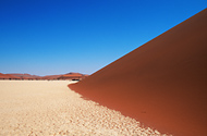
Sossusvlei has the highest sand dunes in the world,
exceeding 1000 feet in height.
Sossusvlei is a 300km by 150km dune expanse stretching from
the Khoichab River in the south to the Kuiseb River in the north.
Sossus Vlei itself is a huge ephemeral pan amid red sand dunes that
tower above the underlying strata. Aside from
the bewitching scenery and geological fascinations held in store
at Sossusvlei and Sesriem Canyon, the area is ideal for observing
some of the dune life for which the Namib is so well known. Early
morning traces in the sand will often tell a tale or two about the
nocturnal activities of the desert's highly adapted insects, spiders,
scorpions and reptiles. For anyone interested in scenic landscape
photography, the Sossusvlei area is almost without equal in the
natural world. Nearby to Sossus Vlei is the amazing Dead Vlei,
with its skeletal Camelthorn trees, a truly surreal place with amazing
vistas. "Big Daddy", one of the world's tallest dunes,
can be climbed for sweeping views of Dead Vlei below and the entire
area
for miles.
The NamibRand
Nature Reserve (Southern Africa's biggest privately owned
reserve) originated as a dream of extending the desert frontiers
by integrating a large
number of former sheep farms and developing a sanctuary free of fences,
so that once again the wildlife could roam their habitat unhindered.
Covering an area of some 200,000 hectares
close to Sossusvlei, NamibRand is bordered by the Naukluft Park in
the west and the impressive Nubib
Mountain range in the East. The special attraction of the reserve is
the diversity of desert landscapes. Virtually all facets of the Namib
are represented here. Mountains plunging down into endless grassy plains,
which are interspersed by red vegetated dunes, create a living tapestry
of colours and shapes that make it a visual utopia for artists and photographers.
Game species found in the reserve include gemsbok, mountain and plains
zebra, springbok, red hartebeest, bat-eared fox, spotted hyena, Cape
fox and African wildcats. The more rocky areas are inhabited by kudu,
klipspringer, baboon and leopard, while the dunes harbour a rich and
diverse micro-fauna. Over a hundred species of birds have been recorded.
Top
Etosha Skeleton
Coast Namib-Naukluft
 Return to Safari Camps & Map
of Namibia
Return to Safari Camps & Map
of Namibia
 For
History and General Information about Namibia, click More
Namibia For
History and General Information about Namibia, click More
Namibia
|