|
Mana
Pools National Park
 Mana Pools National
Park was established in 1963. It lies along Zimbabwe's northern border
on the banks of the Zambezi River, downstream and northeast of Lake Kariba.
The area is rich in wildlife and comprises 2,190 square kilometres. The
Park was inscribed by UNESCO (United Nations Educational, Scientific and
Cultural Organization) as a World Heritage Site in 1984. Mana Pools is
ranked as one of Africa's outstanding wildlife reserves and during the
winter months it has the highest concentration of game in the entire continent.
Huge herds of Elephant and Buffalo are drawn to the sweet Zambezi waters,
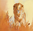
followed by Lion, Hyena, Kudu, Nyala, Impala and a multitude of game. Mana Pools National
Park was established in 1963. It lies along Zimbabwe's northern border
on the banks of the Zambezi River, downstream and northeast of Lake Kariba.
The area is rich in wildlife and comprises 2,190 square kilometres. The
Park was inscribed by UNESCO (United Nations Educational, Scientific and
Cultural Organization) as a World Heritage Site in 1984. Mana Pools is
ranked as one of Africa's outstanding wildlife reserves and during the
winter months it has the highest concentration of game in the entire continent.
Huge herds of Elephant and Buffalo are drawn to the sweet Zambezi waters,
followed by Lion, Hyena, Kudu, Nyala, Impala and a multitude of game.
Mana means ‘four’, in reference to the four large permanent
pools formed by the meanderings of the middle Zambezi. Here the Zambezi
River has left behind the remains of old channels forming small seasonal
pools reaching inland for miles. These small ponds and pools such as Chine
Pools and Long Pool were formed as the river's course slowly drifted northward.
Reeds, sandbanks, and huge Mahogany and Acacia trees near the river give
way to Ebonies and Baobabs, and finally to dense Mopane woodland to the
park's southern boundary along the Zambezi Escarpment.
Mana Pools is one of the least developed National Parks in Southern Africa.
It was saved from a hydro-electric scheme in the early eighties which
would have seen the flooding of this subsequent World Heritage site. It
has the country’s biggest concentration of hippo and crocodiles
and large dry season mammal populations of elephant and buffalo. Sadly,
what was once the densest population of endangered black rhino in the
world is being denuded by poaching despite manned ground patrols.
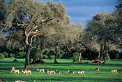
Wildlife commonly seen in the park include Elephant, Buffalo, Waterbuck,
Kudu, Zebra, Eland, Impala, Bushbuck, Lion and Crocodile. Huge pods of
Hippo can be seen lying on the sandbanks soaking up morning sun along
the Zambezi River. Also often seen are Wild Dog, Leopard, Jackal, Hyena
and the rare Nyala. Birding is also fantastic, with large varieties of
woodland and water birds present.
For the adventurous traveler, a canoe trip down on the Mana Canoe Trail
is one of the best ways to experience the African bush. Guests take a
guided canoe safari down the Zambezi river towards Moçambique - a real
African adventure where you have to dodge territorial Hippos and camp
on sandbanks that are visited by elephants at night. The canoe safaris
last anywhere from three to nine days and cover different stretched of
the river from Kariba Dam downstream for up to 160 miles, past Mana Pools
to Kanyemba near the Moçambique border. Paddling in a canoe down the Zambezi
at Mana Pools is one of the most unique safari experiences in Africa -
coming close to great herds without feeling like an intruder, enjoying
the warm African sun - this is an experience for anyone who loves adventure!
Mana Pools is also one of Zimbabwe's best locations for walking safaris
and ranks with the South Luangwa (in Zambia) and Botswana's Selinda area
as one of the best in Southern Africa. Mana Pools is the only game park
in Zimbabwe harbouring carnivores and the larger mammals in which visitors
are allowed to walk unaccompanied by guides - a holdover from colonial
times. The eastern part of Mana Pools has been designated a wilderness
area in which only walking and canoeing along its shores are allowed.
There are no roads or other signs of man.
The best time to visit the park for wildlife viewing is at the end of
the dry season (August-October) when large numbers of Elephant, Buffalo,
Waterbuck and Impala come to the river to drink and graze along its banks.
Game viewing is also very good in June and July. During the rainy season,
much of the game moves off away from the river towards the escarpment.
Matusadona
National Park
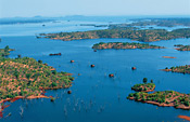 Matusadona is situated
on the southern shore of Lake Kariba and bounded on the east by the dramatic
Sanyati Gorge and the west by the Umi River. The park contains an abundance
of wildlife, especially Elephant, Lion, Kudu, Impala and Buffalo. Two
thirds of this 1500 km² national park is accessible only by foot.
Comprising wooded hills, plateau and shoreline, the park itself is not
easy to get to by road, even in a 4x4, and is most easily accessed by
boat from Kariba. Matusadona is a melodic word in the local dialect for
“constant dripping of dung” in reference to the huge elephant
population which took to these high grounds after their relocation in
Operation Noah. The rugged mountains of the Zambezi escarpment dominate
the backdrop. Matusadona is situated
on the southern shore of Lake Kariba and bounded on the east by the dramatic
Sanyati Gorge and the west by the Umi River. The park contains an abundance
of wildlife, especially Elephant, Lion, Kudu, Impala and Buffalo. Two
thirds of this 1500 km² national park is accessible only by foot.
Comprising wooded hills, plateau and shoreline, the park itself is not
easy to get to by road, even in a 4x4, and is most easily accessed by
boat from Kariba. Matusadona is a melodic word in the local dialect for
“constant dripping of dung” in reference to the huge elephant
population which took to these high grounds after their relocation in
Operation Noah. The rugged mountains of the Zambezi escarpment dominate
the backdrop.
The Lake Kariba shoreline is home to large concentrations of Buffalo,
Waterbuck, Impala and Zebra, especially during the dry months from May
to October. Elephant bulls are almost always in view close to the water.
Rhino are present but elusive in the hills and woodland areas. Lion,
Leopard, Warthog, Kudu and Bushbuck are endemic. Because of the lake
and vegetation diversity, an extraordinary variety of birdlife can be
found. Lion are plentiful and on average, a Crocodile inhabits every
200m of shoreline. Birdlife includes Fish Eagles, Storks, Herons and
even Flamingos. The Zambezi River is Tiger Fish territory; the Tiger
is a renowned fighting fish that can reach 15kg in weight. The dam supports
an annual Tiger fishing tournament which is immensely popular. Matusadona
is a great spot for guided game walks and its drowned forests, relics
of the flooded dam, provide irresistible sunset photo opportunities.
The Kariba Dam and Operation Noah
The Zambezi River has always been the artery of Central
Africa. Shortly before World War II a report was made on the possibility
of building a hydroelectric scheme in the area and in 1950 a start was
made. New settlements were made for the BaTonga people of the valley -
it was a heart-rending sight and they were loathe to abandon Nyaminyami,
their River God. Between 1956 and 1961 at the head of the deep Kariba
Gorge, a 128-metre high concrete dam wall was built. By early 1959 when
the dam wall was complete, the plains began to flood. Behind the wall,
Lake Kariba was born, stretching back for 290km, covering 6,000 sq km,
(42km across at its widest point) with an average depth of 18 metres.
One of Africa's most ambitious projects came to life when Queen Elizabeth
officially started the generators on May 16th, 1960.
Operation Noah, was borne in 1959 shortly after the
dam wall was completed in 1959. The project was aimed at rescuing wild
animals, most of them Sable and other antelopes, which were trapped on
many islands by the rising waters of Lake Kariba. As the dam was sealed
and the waters began to rise the wild animals in the area gradually made
way moving to higher ground. Many of these animals found themselves stranded
on islands with little or no hope of getting off, or even of survival.
The game departments of the then Northern and Southern Rhodesia (now Zambia
and Zimbabwe) set out to rescue these animals and Operation Noah was set
in motion. By the end of 1959 over 6,000 animals, Elephant, various buck,
Rhino, Lion, Leopard, Zebra, Warthog, snakes and thousands of other reptiles,
smaller animals and birds had been rescued. Animals were trapped, darted
and transported by boat to safety and set free again. Many swam to safety
after being herded into the waters, but others which could not swim such
as rhino were trussed to rafts and taken to safety.
Hwange
National Park
 At 14,650 km²,
Hwange is the largest national park in Zimbabwe. The park is located in
the northwest corner of the country, just west of the road connecting
Bulawayo with Victoria Falls. The park ranges from semi-desert in the
south to a plateau in the north. The northern portion of Hwange is mudstone
and basalt, and the southern portion is Kalahari sand veld. The salt pans,
acacia scrub and grassy plains support an abundance of game, but this
has not always been so. These sands have seen a lot of blood, from both
man and beast. Consider the history: Hwange was an early African chief
who was ousted by the invading Ndebele tribe and the lands taken over
as a royal hunting ground. At 14,650 km²,
Hwange is the largest national park in Zimbabwe. The park is located in
the northwest corner of the country, just west of the road connecting
Bulawayo with Victoria Falls. The park ranges from semi-desert in the
south to a plateau in the north. The northern portion of Hwange is mudstone
and basalt, and the southern portion is Kalahari sand veld. The salt pans,
acacia scrub and grassy plains support an abundance of game, but this
has not always been so. These sands have seen a lot of blood, from both
man and beast. Consider the history: Hwange was an early African chief
who was ousted by the invading Ndebele tribe and the lands taken over
as a royal hunting ground.
When the white man came in the 19th century,
they promptly set about claiming land and finishing off the remaining
game. Then fate stepped in. As population pressures increased, the country’s
animals were pushed further and further into the inhospitable western
reaches on the Botswana border where Hwange lies, and the national park
came about primarily by default. It has been a park now for 70 years and
has the densest concentration of wildlife in Africa with great herds of
buffalo and elephant and all the "big five".
Hwange (previously called Wankie), is famous for its large herds of Elephant.
Other predominant species include Buffalo, Giraffe, Zebra, Wildebeest,
Lion, Cheetah, Wild Dog, Kudu, Hyena, Impala, Roan Antelope, Waterbuck,
Tsessebe, Black-backed Jackal and Bat-eared Fox. This is also one of the
best places in Africa to see Sable Antelope. Hwange contains over 100
species of mammal and 400 species of birds. Game viewing is made easier
by the shallow pans threaded throughout the park. These natural salt-licks,
brought to the surface by the excavation of ants, provide the Elephants
with favourite mudholes. They ultimately become small ponds, some 20 or
30 metres around.
Generally, there are no seasonal
animal migrations. The best time to view wildlife is during the dry season,
from July to October, when the game concentrates near the permanent water.
Game viewing is also good during May, June and November and fairly good
from December through April. During the rainy season, from January to
March, the game is widely dispersed into the Mopane woodland.
Matobo
(Matopos) National Park
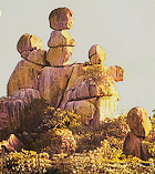 The Matobo Hills, some 25 miles south
of Bulawayo, are remarkable for their unusual scenery and the diversity
of their flora and fauna. They are also a focal point of much of Zimbabwe's
history and prehistory. The hills cover about 790,000 acres and have been
eroded from an exposed granite batholith thought to be over 300 million
years old. Hump-backed domes ('dwalas') have resulted from exfoliation
of the granite; crenellated ridges, often surmounted by remarkable 'balancing
rock' formations, have been formed by erosion along regular fault lines
in the rock. In most of the area the hills are aligned into steep ridges,
often densely wooded on their lower slopes, and separated by valleys containing
numerous streams, springs, seeps and vleis. They support a flora ranging
from lichens, figs and aloes to Brachystegia species, Mopane trees and
over 100 grass species. The Matobo Hills, some 25 miles south
of Bulawayo, are remarkable for their unusual scenery and the diversity
of their flora and fauna. They are also a focal point of much of Zimbabwe's
history and prehistory. The hills cover about 790,000 acres and have been
eroded from an exposed granite batholith thought to be over 300 million
years old. Hump-backed domes ('dwalas') have resulted from exfoliation
of the granite; crenellated ridges, often surmounted by remarkable 'balancing
rock' formations, have been formed by erosion along regular fault lines
in the rock. In most of the area the hills are aligned into steep ridges,
often densely wooded on their lower slopes, and separated by valleys containing
numerous streams, springs, seeps and vleis. They support a flora ranging
from lichens, figs and aloes to Brachystegia species, Mopane trees and
over 100 grass species.
The park is divided into two sections - a general recreation area where
horseback riding trails are popular, and a game reserve. Matobo has the
highest concentrations of Black Eagles in the world. The park also contains
one of the highest concentrations of Black and White Rhinos remaining
in Africa. Leopard are plentiful but are seldom sighted. Other wildlife
includes Giraffe, Zebra, Civet, Genet, Black-backed and Side-striped
Jackal,
and Caracal. Birding is good and species include Purple-crested Louries,
Crowned Eagles, Peregrine Falcons and Lannar Falcons.
Human habitation in the Matobo Hills stretches back at least 40,000 years.
The evidence for this long period of habitation comes from the deep layers
of human detritus excavated from the many caves and rock shelters in the
hills. The Matobo region is particularly well known for the number and
quality of its Stone Age rock art sites. The region has over 3,000 known
rock paintings - more than any other place in Africa. Among the most important
are Nswatugi Cave, Bambata Cave, Silozwane and Pomongwe. This has long
been sacred ground and amongst the cracks and crevices of the Matobo Hills
is the Ndebele’s rain shrine to Mwari, the god of their ancestors.
The Motopos Hills were the scene of the famous indaba between Cecil Rhodes
and Ndebele leaders in 1896. Rhodes (after whom Rhodesia was named) is
buried here (on the summit of Malindidzimu, the 'hill of the spirits')
at his own request, but there has been some controversy over whether he
will stay. The spiritual struggle between the resting place of Rhodes
and the rights of the Mwari is a political tug of war. Should it be the
park, or the people, who have been squeezed out by farmlands and nature
reserve? At present, the park survives, guarding its rhino from poachers
and its rock art from the rain. The people survive outside its boundaries
but do come in to cut thatch.
The hills were named Amatobo, meaning the 'bald-headed ones', by the Ndebele
king, Mzilikazi; later this was corrupted to 'Matopo' by white settlers.
The Matopos National Park is a candidate for World Heritage status under
the UNESCO World Heritage convention because of its outstanding cultural
and natural importance.
Some 105,000 acres of the Matopos Hills region is now included in the
Matobo (Matopos) National Park, which dates back to 1904 when a game enclosure
was established on the northern edge of Matobo Hills and stocked with
Sable antelope, Waterbuck, Reedbuck, Zebra, Eland, Giraffe and a Camel.
Formerly called ‘Rhodes Matopos National Park’, this is one
of the most undersold national parks in Zimbabwe.
 Mana Pools Matusadona Hwange Matobo
Top  Return to Safari Camps & Map of
Zimbabwe
Return to Safari Camps & Map of
Zimbabwe
 For
History and General Information about Zimbabwe, click More
Zimbabwe For
History and General Information about Zimbabwe, click More
Zimbabwe
|