Summary
 Botswana's
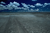
great Sua and Ntwetwe Pans collectively comprise the 12,000 sq km
Makgadikgadi Pans. The grassy Makgadikgadi Pans National Park includes
only a portion of Ntwetwe Pan. These landscapes are like no other
on earth; especially in the sizzling heat of late winter, the stark
pans take on a disorienting and ethereal austerity. Heat mirages
destroy all sense of space or direction, imaginary lakes shimmer
and disappear, ostriches fly, and stones turn to mountains and float
in mid-air. These are just tricks that the heat waves cause our eyes
to imagine. Botswana's
great Sua and Ntwetwe Pans collectively comprise the 12,000 sq km
Makgadikgadi Pans. The grassy Makgadikgadi Pans National Park includes
only a portion of Ntwetwe Pan. These landscapes are like no other
on earth; especially in the sizzling heat of late winter, the stark
pans take on a disorienting and ethereal austerity. Heat mirages
destroy all sense of space or direction, imaginary lakes shimmer
and disappear, ostriches fly, and stones turn to mountains and float
in mid-air. These are just tricks that the heat waves cause our eyes
to imagine.
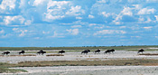
In September, herds of Wildebeest, Zebra and other antelope move
into the thirsty grasslands west of the pans to await the first rains.
Although the water is short-lived, wildlife gravitates towards depressions
that retain stores of water after the surface moisture has evaporated.
Around December, the deluge of rain begins. The fringing grasses
turn green and the herds arrive to partake of the bounty. Flamingos,
pelicans, ducks, geese and other water birds flock to the mouth of
the Nata River to build shoreline nests and feed on algae and tiny
crustaceans that have lain dormant in the salty earth during the
dry months. |
Geology
The Makgadikgadi Pans are the residue
of a great lake that once covered much of northern Botswana, fed by rivers
carrying salts leached from the lake's catchment area. Ancient lakeshore
terraces reveal that the water depth fluctuated by as much as 33 metres
and, at its greatest extent, the lake covered an area of 60,000 sq km.
Because the basin had no outlet, the salts were concentrated in low lying
areas. Less than 10,000 years ago, climactic changes caused the lake
to evaporate, leaving only salt deposits.
Sua Pan
Sua Pan is mostly a single sheet of salt-encrusted mud stretching across
the lowest basin in north-eastern Botswana. Sua means salt in the
language of the San, who once mined the pan to sell salt to the
Kalanga people. In wet season of normal rainfall, flocks of water-loving
birds gather to nest at the delta where the Nata River flows into
the northern end of Sua Pan. At these times, its expanses are covered
with a film of water only a few centimetres deep, creating an eerie
and surreal effect that reflects the sky and obliterates the horizon.
Nata Sanctuary: The
230 sp km Nata Sanctuary is a community project designed as a refuge
for the wildlife on and around Sua Pan (45% of the reserve is on
the pan). The idea
was first raised in 1988 by the Nata Conservation Committee and the sanctuary
was realized four years later, thanks to the Kalahari Conservation Society and
funding from national and international organizations. Local people voluntarily
relocated 3500 cattle onto adjacent rangeland and established a network of dust
roads.
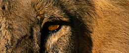
Mammal species are restricted to antelope - Hartebeest, Kudu, Reedbuck, Springbok
and Steenbok; also Springhares, jackals, foxes, monkeys and squirrels. Eland,
Gemsbok and Zebra are being reintroduced. However, most of the wildlife has wings
and around 165 species - from kingfishers and bee-eaters to eagles, bustards
and Ostriches - have been recorded. There are also numerous savanna and woodland
bird species. When the Nata River flows, this corner of Sua Pan becomes a paradise
for water-loving birds from all around Africa: ducks, teals, geese, and hosts
of pelicans, spoonbills and both Greater and Lesser Flamingos.
 Kubu Island: Near
the south-western corner of Sua Pan lies Kubu Island, the original
desert island. But for one tenuous finger of grass, the ancient 20-metre
high
scrap of rock and its ghostly Baobabs lies surrounded by a sea of salt.
In cool weather, this bizarre sight can make visitors feel like castaways
on an alien planet. In Zulu-based languages, 'Kubu' means Hippopotamus,
and as unlikely as it may seem, given the current environment, the site
may have been inhabited as recently as 500 to 1500 years ago. On one
shore lies an ancient crescent-shaped stone enclosure of unknown origin
that has yielded numerous pot shards, stone tools and Ostrich eggshell
beads. Kubu Island: Near
the south-western corner of Sua Pan lies Kubu Island, the original
desert island. But for one tenuous finger of grass, the ancient 20-metre
high
scrap of rock and its ghostly Baobabs lies surrounded by a sea of salt.
In cool weather, this bizarre sight can make visitors feel like castaways
on an alien planet. In Zulu-based languages, 'Kubu' means Hippopotamus,
and as unlikely as it may seem, given the current environment, the site
may have been inhabited as recently as 500 to 1500 years ago. On one
shore lies an ancient crescent-shaped stone enclosure of unknown origin
that has yielded numerous pot shards, stone tools and Ostrich eggshell
beads.
|
Sua Spit: Sua
Spit, about a 10 minute drive north of the Dukwe buffalo fence, is a long,
slender protrusion extending into the heart of Sua Pan. It is the nexus
of Botswana's lucrative soda ash industry.
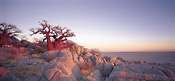
Ntwetwe Pan
Convoluted Ntwetwe Pan covers more area than its eastern counterpart, Sua Pan.
It was once fed by the waters of the Boteti River, but they were diverted
at Mopipi Dam to provide water for the Orapa diamond mine and the pan is
now almost permanently dry. The western shore of Ntwetwe Pan is probably
the most interesting in the Makgadikgadi area, with landscapes of rocky
outcrops, dunes, islets, channels and spits.
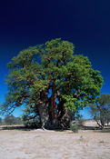 Green's & Chapman's
Baobabs: At
ephemeral Gutsa Pan, 30 km due south of Gweta, rises Green's Baobab,
which was inscribed by the 19th century hunter and trader Joseph
Green and Ghanzi founder Hendrick van Zyl, among other characters.
Fifteen km to the south-east by rough track is the enormous Chapman's
Baobab, which measures 25 metres around and historically served as
a beacon in a country of few landmarks. It's thought that it was
also used as a post office by passing explorers, traders and travellers,
many of whom left inscriptions on its trunk. It's frequently claimed
that this is the largest tree in Africa. Green's & Chapman's
Baobabs: At
ephemeral Gutsa Pan, 30 km due south of Gweta, rises Green's Baobab,
which was inscribed by the 19th century hunter and trader Joseph
Green and Ghanzi founder Hendrick van Zyl, among other characters.
Fifteen km to the south-east by rough track is the enormous Chapman's
Baobab, which measures 25 metres around and historically served as
a beacon in a country of few landmarks. It's thought that it was
also used as a post office by passing explorers, traders and travellers,
many of whom left inscriptions on its trunk. It's frequently claimed
that this is the largest tree in Africa. |
Gabatsadi Island: The
enormous barchan (crescent) dune known as Gabatsadi Island may see
only a handful of visitors each year, but the expansive view from
the crest has managed to attract the likes of Prince Charles, who
went to capture the indescribably lovely scene in watercolor. It
lies west of the Gweta-Orapa track, 54 km south of Gweta.
Makgadikgadi & Nxai Pan National Park
Because of their complementary natures regarding wildlife migrations, Makgadikgadi
Pans Game Reserve and Nxai Pan National Park were established concurrently
in the early 1970s, in the hope of protecting the entire ecosystem. In
1992, when the tarred highway was built, Nxai Pan National Park was extended
south to the road to take in Baines' Baobabs, and the two parks are now
administered as one entity.
 Makgadikgadi Pans Game Reserve: The
Makgadikgadi Game Reserve section of the National Park is a 3900
sq km tract of pans, grasslands and beautiful savanna country. Wildlife
is plentiful but since the reserve is unfenced, animals may wander
in and out at will, and you won't see the artificially high numbers
found at Chobe. During the winter dry season, animals concentrate
around the Boteti River, but between February and April, huge herds
of Zebra and Wildebeest migrate north to Nxai Pan and beyond, only
returning to Boteti when the rains diminish around early May. Makgadikgadi Pans Game Reserve: The
Makgadikgadi Game Reserve section of the National Park is a 3900
sq km tract of pans, grasslands and beautiful savanna country. Wildlife
is plentiful but since the reserve is unfenced, animals may wander
in and out at will, and you won't see the artificially high numbers
found at Chobe. During the winter dry season, animals concentrate
around the Boteti River, but between February and April, huge herds
of Zebra and Wildebeest migrate north to Nxai Pan and beyond, only
returning to Boteti when the rains diminish around early May.
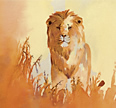
The range of antelope includes Impala, Gemsbok, Hartebeest and Kudu,
but they only appear in large numbers during the immigrations during
May and June. Lion, Hyena and Cheetah are also present and when there's
water, the Boteti River supports a healthy Hippo population. You'll
also see a stunning array of birds, but as there are no reliable
water sources, Elephant and Buffalo wander in only during extremely
wet seasons. |
Nxai Pans Section: After
the amalgamation of the Makgadikgadi and Nxai Pan national parks,
the Nxai Pan region was expanded from around 2100 sq km to over 4000
sq km. Nxai Pan lies on the old Mpandamatenga Trail, which connected
a series of boreholes and was used until the 1960s for overland cattle
drives between Ngamiland and Kazungula.
Kudiakam Pan and Nxai Pan
are both a part of the ancient lake bed that formed Sua and Ntwetwe
Pans. Kudiakam is comprised of mini salt pans, but thanks to its
higher elevation, Nxai Pan escaped encrustation by leached salts.
The Nxai Pan region is speckled with Acacia Tortilis trees and resembles
the Serengeti (without all the safari vehicles). In the dry season,
wildlife activity concentrates on one artificial water hole, just
north of the Game Scout Camp, but in the February to April wet season,
Nxai Pan comes alive. The wildlife herds in Nxai's grassy plains
can be staggering; Wildebeest, Zebra and Gemsbok appear in the thousands,
along with large herds of other antelope and Giraffe. Bat-eared Foxes
emerge in force and Lion, Hyena and Wild Dogs come in to gorge on
the varied menu.
Baines' Baobabs: Originally
known as the Sleeping Sisters, this hardy clump of Baobabs was immortalized
in paintings by artist and adventurer Thomas Baines on 22 May 1862.
Baines, a resourceful self-taught naturalist, artist and cartographer,
first came to Botswana in 1861, and travelled with trader and naturalist
John Chapman from Namibia to Victoria Falls. He had originally been
a member of David Livingstone's expedition to the Zambezi, but was
mistakenly accused of theft by Livingstone's brother and forced to
leave the party. Livingstone later realized the mistake, but never
admitted it and Baines remained the subject of British ridicule.
The stately cluster of trees isn't particularly special, but when
the pan contains water, they present a lovely scene. A comparison
with Baines' paintings reveals that in well over 100 years, only
one branch has disassociated itself. When the new Nata-Maun road went
through, Baines' Baobabs were incorporated into Makgadikgadi and
Nxai Pan National Park.
Bushman Pits: On
the western boundary of the park lie the Bushman Pits. Here, ancient
San people dug pits where they could hide while hunting animals that
had come to drink at the waterhole. These bunkers may still be seen
around the waterhole.
(The above information was excerpted from The Lonely Planet Guide to Botswana).
 Top
Top  Return
to Map of Makgadikgadi Return
to Map of Makgadikgadi
 Water
/ Land Activity Table for Botswana camps: Water/Land
Botswana Water
/ Land Activity Table for Botswana camps: Water/Land
Botswana
Flying
Times between Botswana camps: Fly
Times Botswana
|